
Streamcombe Valley
Where does Wildwood Grove sit within the Streamcombe Valley headwater system?
Evidence Sources
The information presented on this page is derived from:
LiDAR topographic analysis
Historic Ordnance Survey mapping
River Restoration Centre hydrological assessment, 2026
Site observations undertaken during 2025–2026
Overview
Wildwood Grove is situated within the upper Streamcombe Valley near Dulverton, Somerset.
The Streamcombe Valley forms part of the River Brockey sub-catchment within the wider River Exe catchment. The valley comprises a series of headwater slopes, spring emergence zones, tributaries and watercourses that collect and convey water from the surrounding landscape towards the River Brockey.
Wildwood Grove occupies part of this wider headwater valley system.
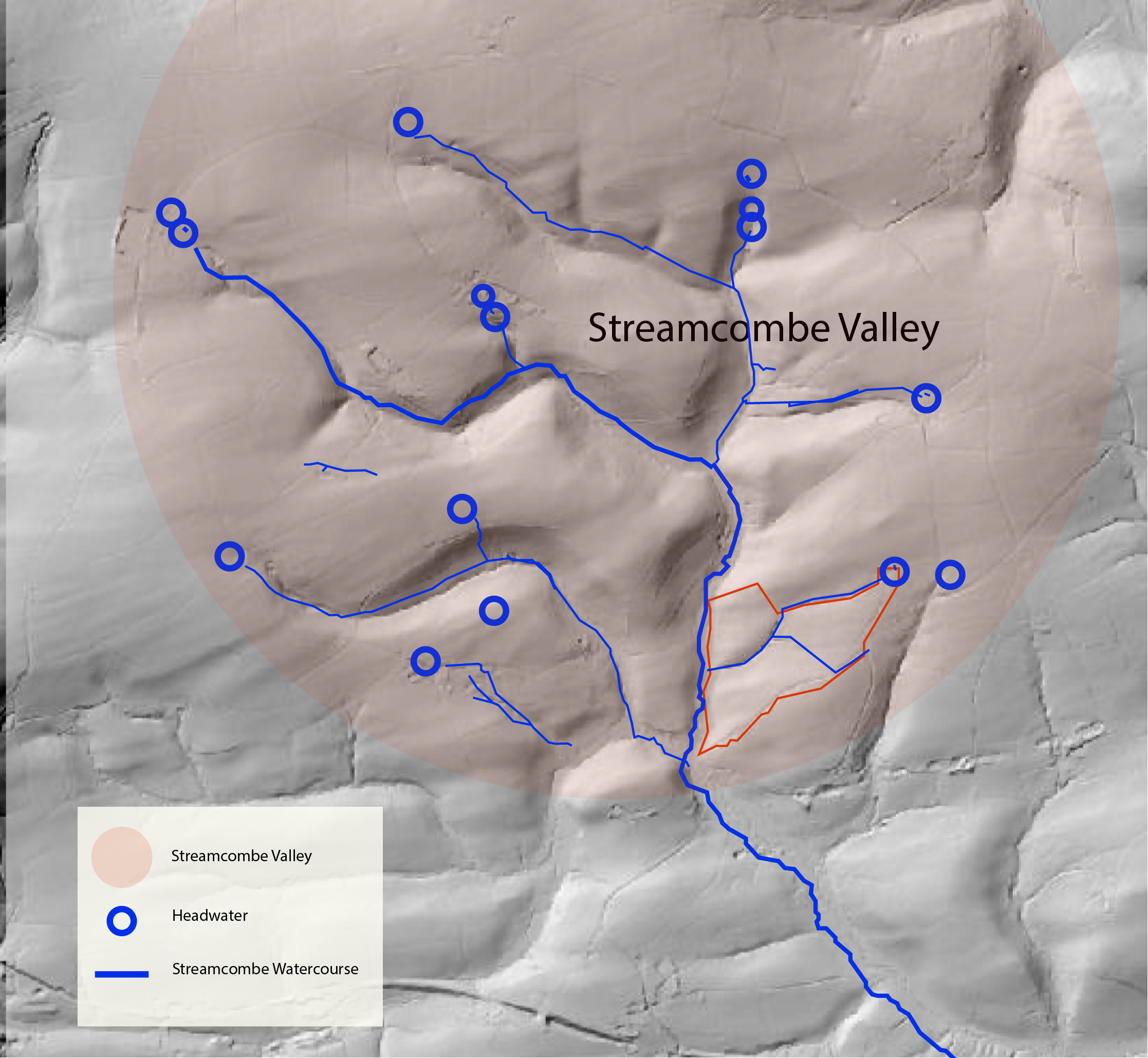
Valley Landform
LiDAR analysis identifies Streamcombe as a small upland valley incised into the surrounding landscape.
The valley is characterised by converging slopes that direct water towards a central drainage corridor. A series of subsidiary valleys and headwater depressions are visible within the upper catchment, creating a branching network of flow pathways that converge within the main valley.
The present valley form reflects the long-term interaction of topography, groundwater emergence and surface water movement.
Headwater System
The upper Streamcombe Valley contains multiple headwater sources distributed across the surrounding slopes.
LiDAR mapping identifies a network of small tributaries and drainage pathways that originate within these headwater areas before converging into the Streamcombe watercourse.
Wildwood Grove forms one component of this wider headwater network. Water originating within the site enters the Streamcombe system alongside contributions from other headwater sources located elsewhere within the valley.
Springs
Historic mapping and field observations record multiple spring locations within the upper Streamcombe Valley.
In addition to springs recorded within Wildwood Grove, further spring emergence points are present elsewhere within the valley head. Historic records indicate that groundwater emergence has been a long-standing feature of the landscape.
These springs contribute water to wet ground, drainage pathways, tributaries and watercourses throughout the headwater system.
Streamcombe Watercourse
The Streamcombe watercourse forms the principal drainage corridor within the valley.
Headwater flows originating from springs, tributaries and surface drainage pathways converge into this channel before continuing downstream towards the River Brockey.
The watercourse provides the primary hydrological connection between the valley headwaters and the wider catchment.
Wildwood Grove Within the Valley
Wildwood Grove occupies part of the eastern side of the Streamcombe Valley headwater system.
The site’s springs, ditches, tributaries and watercourses form part of the wider network of hydrological features present within the valley. Water leaving the site enters the Streamcombe watercourse and continues downstream through the River Brockey and River Exe catchment.
Wildwood Grove is therefore one component of a larger headwater landscape extending beyond the site boundary and encompassing the wider Streamcombe Valley.
Figure 1. Streamcombe Valley headwater landform
LiDAR or mapping evidence showing the wider valley, converging slopes, headwater sources and the position of Wildwood Grove within the Streamcombe system.