
Hydrology
What hydrological features currently exist at Wildwood Grove?
Evidence Sources
The information presented on this page is derived from:
River Restoration Centre site assessment, February–March 2026
Historical agricultural drainage scheme map, 1966
Ecological baseline survey, 2025
Site topographic mapping and LiDAR analysis
Site observations undertaken during 2025–2026
Overview
Wildwood Grove occupies approximately 11.7 hectares within the upper Streamcombe Valley, a headwater valley located within the River Brockey sub-catchment of the wider River Exe catchment. The site consists of three agricultural fields situated on sloping ground draining towards a central watercourse system.
The site lies within a headwater landscape where groundwater, springs, surface water, ditches and watercourses interact across the valley system.
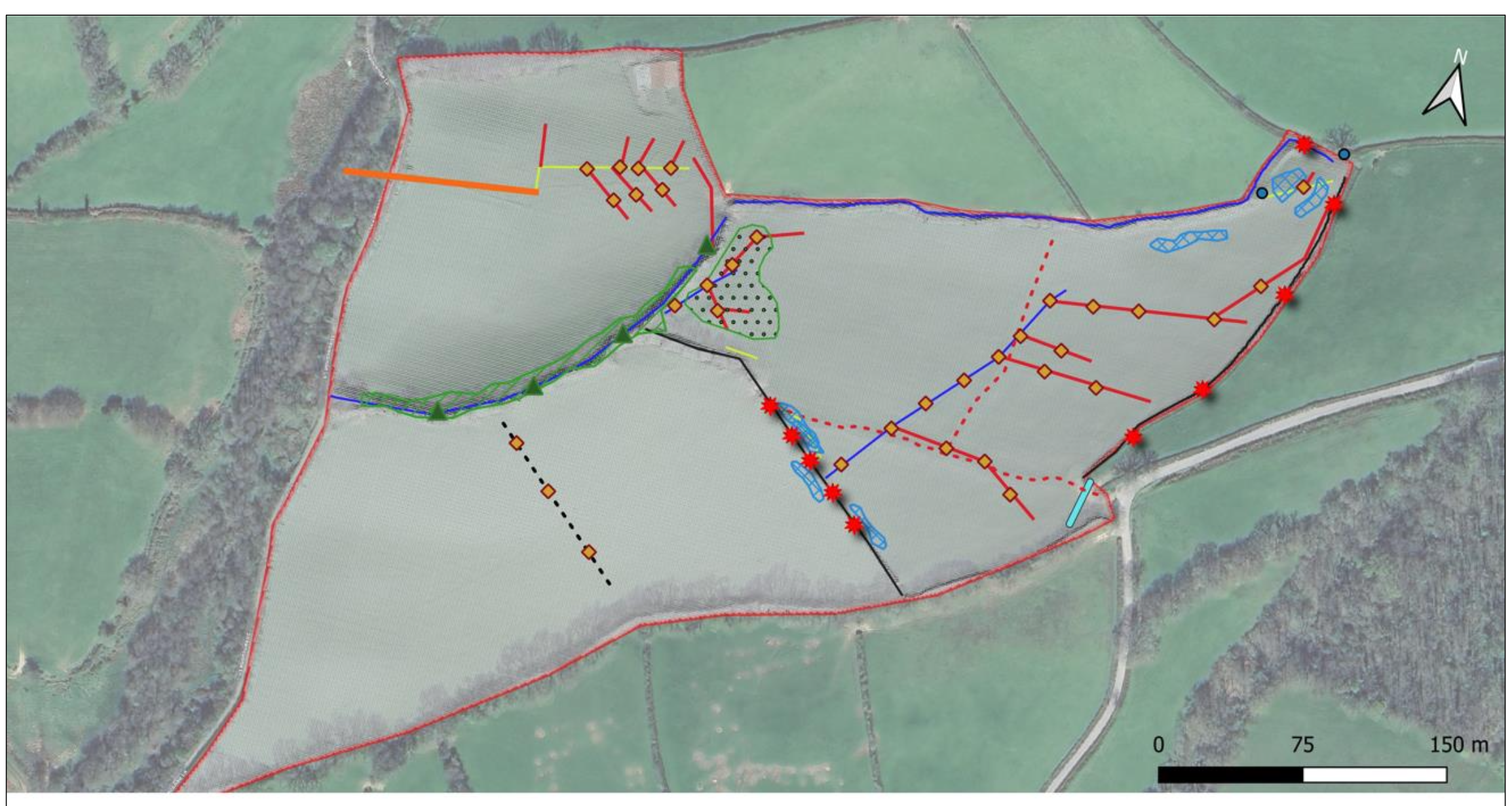
Figure 1. Current hydrological features
Plan showing spring emergence, ditches, main stream, secondary stream, drainage connections, culverted outflow and downstream flow direction.
Headwater Setting
Wildwood Grove is situated within the Streamcombe Valley headwater system.
Mapping of the wider valley identifies multiple headwater sources distributed across the surrounding slopes. These headwaters converge through a network of small tributaries which combine to form the Streamcombe watercourse before flowing downstream towards the River Brockey.
The Wildwood Grove watercourse forms one component of this wider headwater network.
Springs
The underlying Baggy Sandstone bedrock supports groundwater-fed springs within the site. Springs are recorded on historical mapping and remain visible in the same locations today.
A spring located within the north-eastern area of the site collects into a seasonally wet and ponded area adjacent to neighbouring land. Additional groundwater emergence points are present within the upper parts of the site.
These springs contribute water to ditches, wet ground and surface flow pathways across the site.
Watercourses
The site contains a connected network of ditches, tributaries and streams.
The ecological survey recorded:
Approximately 249 metres of main stream
Approximately 63 metres of secondary stream
Approximately 144 metres of ditch habitat
within the surveyed area.
The ditch network converges near the centre of the site before discharging into a more natural channel which exits beneath Streamcombe Lane through a culvert and joins the wider Streamcombe watercourse.
Surface Water Movement
Surface water movement follows the natural valley topography.
Water originating from springs, rainfall and upslope catchment areas moves downslope through a combination of:
Surface flow pathways
Field-edge ditches
Subsurface drainage systems
Tributary channels
The main watercourse
Flow direction generally follows the site’s natural gradient towards the valley floor and downstream watercourse network.
Agricultural Drainage Infrastructure
A certified drainage scheme dated 1966 records the installation of an extensive agricultural field drainage network across parts of the site.
The drainage plan identifies:
12-inch concrete collector drains
6-inch concrete drains
6-inch field drains
4-inch field drains
3-inch field drains
connected to a series of outfalls and drainage channels.
The mapped drainage network is concentrated principally within the northern and eastern fields and connects to field boundary ditches and receiving watercourses.
The River Restoration Centre assessment records that the subsurface drainage system remains connected to the ditch network present on site today.
Ditches
Field boundaries contain a network of drainage ditches associated with the historical agricultural drainage system.
The River Restoration Centre recorded ditch depths generally ranging between approximately 1 and 2 metres along sections of the site boundary network.
These ditches receive water from both springs and subsurface drainage infrastructure before conveying flow towards the central watercourse system.
Groundwater
The site is underlain by the Baggy Sandstones Formation. Both geological mapping and hydrogeological assessments identify groundwater interaction within the site.
Groundsure mapping classifies the underlying bedrock as a Secondary A Aquifer.
Groundwater emergence is expressed on site through springs, wet ground and sustained baseflow within the watercourse network.
Hydrological Components Present
The hydrological features currently recorded at Wildwood Grove include:
Groundwater-fed springs
Secondary A aquifer geology
Surface water flow pathways
Seasonally wet ground
Field-edge ditches
Subsurface agricultural drainage infrastructure
Tributary channels
Main watercourse channels
Culverted outflow beneath Streamcombe Lane
Connection to the wider Streamcombe Valley headwater system