
Drainage History
How has water management at Wildwood Grove changed through time?
Evidence Sources
The information presented on this page is derived from:
Historic Ordnance Survey mapping
Historic spring records
Certified agricultural drainage scheme plan, 1966
LiDAR analysis
River Restoration Centre site assessment
Site observations
Monitoring records
Overview
Wildwood Grove contains evidence of both natural spring-fed hydrology and later agricultural drainage engineering.
Historic mapping records springs and natural water movement within the present holding. Later drainage records show the installation of a certified agricultural drainage scheme across parts of the site in 1966. Present-day observations confirm that spring emergence, wet ground, ditches, drains and watercourses remain active components of the landscape.
The current drainage system therefore reflects successive phases of water management: natural headwater formation, mapped spring-fed water movement, agricultural drainage installation, engineered conveyance and the present-day monitored system.
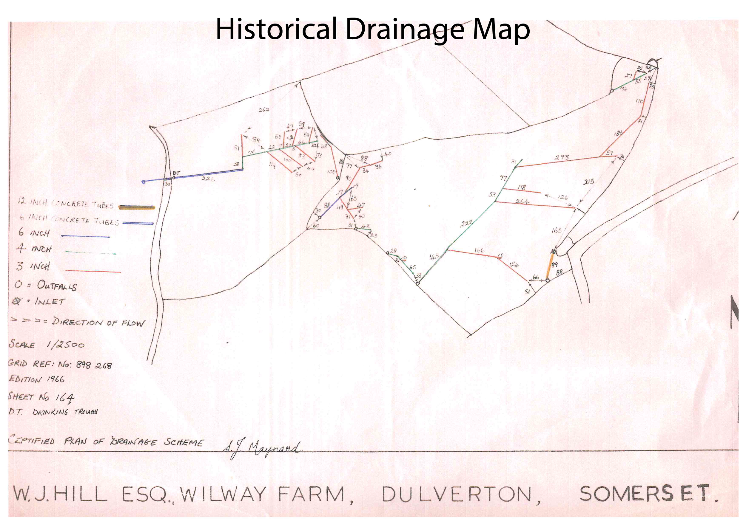
Figure 1. Certified agricultural drainage scheme, 1966
Historic drainage plan recording lateral field drains, collector drains, pipe drainage infrastructure, outfalls, pipe diameters and designed flow directions.
Historic Spring System
Historic mapping records multiple spring features within the present holding.
Mapped features include both:
Spring
Springs
located within the eastern part of the site.
Historic mapping also records water emerging from the upper slopes before moving downslope through natural drainage pathways.
LiDAR analysis identifies a distinct headwater valley system extending through the site and connecting to the wider Streamcombe valley system.
Present-day observations confirm ongoing groundwater emergence within the same general locations recorded on historic mapping.
Spring-fed hydrological features were present within the site prior to the installation of the documented agricultural drainage network.
The natural headwater system predates subsequent agricultural drainage works.
Historic Water Movement
Historic mapping records natural drainage pathways extending downslope from mapped spring locations.
LiDAR analysis identifies valley features and natural flow routes extending through the holding toward the Streamcombe valley.
Present-day field observations identify continuing surface and subsurface water movement along similar topographic pathways.
Water movement through the site historically followed the underlying topography of the headwater valley system.
The principal drainage pathways remain identifiable within the modern landscape.
Agricultural Drainage Installation
A certified agricultural drainage scheme was installed across parts of the holding.
The drainage plan records:
Lateral field drains
Collector drains
Pipe drainage infrastructure
Engineered outfalls
Designed flow directions
The drainage network incorporates multiple pipe sizes including:
3-inch pipes
4-inch pipes
6-inch concrete pipes
12-inch concrete pipes
The drainage system was designed to collect and convey water toward defined discharge locations.
The drainage scheme represents a documented phase of agricultural land improvement.
Water movement within parts of the site became partially controlled through engineered drainage infrastructure.
Agricultural Improvement and Drainage Engineering
The drainage layout demonstrates a planned engineering approach to agricultural water management.
Drainage laterals connect to collector drains before discharging through engineered outfalls.
Drainage infrastructure is concentrated within areas associated with springs, wet ground and natural drainage pathways.
The drainage network was constructed to improve agricultural land management through the interception and conveyance of water.
The drainage system remains a physical component of the contemporary landscape.
Drainage Ditches and Conveyance Features
Boundary ditches are present throughout parts of the holding.
Historic drainage infrastructure connects with ditch systems located along field boundaries.
Water from springs, drains and surface flow pathways converges toward the central watercourse before leaving the site beneath Streamcombe Lane.
The contemporary drainage system consists of both natural and engineered components.
Springs, drains, ditches and the watercourse collectively influence water movement through the site.
Present-Day Drainage System
Water emergence remains visible within areas recorded historically as spring locations.
Seasonal wet ground, saturated soils and surface water movement continue to occur within parts of the holding.
Historic drainage infrastructure remains evident within the landscape.
Natural hydrological features remain identifiable alongside engineered drainage features.
The present drainage system reflects the combined influence of:
Natural spring-fed hydrology
Historic drainage engineering
Agricultural land management
Contemporary hydrological processes
The current landscape retains evidence of both the original headwater system and subsequent agricultural drainage modification.
Historical Water Management Timeline
Available evidence records multiple phases of water management within the site:
Natural spring-fed headwater system
Mapped spring landscape
Agricultural drainage installation
Engineered drainage management
Present-day monitored system
The current drainage pattern reflects successive phases of landscape development and water management that remain identifiable within the site today.
From drainage history to system response
The drainage history explains how water management has changed the physical behaviour of the site.
Fresh Start Solutions is being created to examine how environmental function can be re-expressed, monitored and compared through a controlled headwater system.